Flood Warnings Issued for the Missouri River
Very Heavy Rainfall Results in Rapid Rise of Water Levels
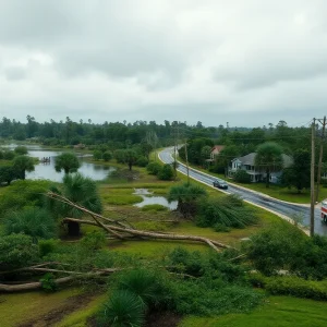
The previously tranquil Missouri River has become a cause for concern as it experiences a large surge of water due to heavy rainfall over the last couple of weeks across northern Nebraska, South Dakota, Minnesota, and northwest Iowa. As reported, parts of northwest Iowa experienced major to record-setting flooding over the weekend, triggering several evacuations and causing significant damage.
All of the water now converging into the Missouri River will eventually have to move downstream from its entry point around Sioux City, thereby increasing the flood hazard along its path.
Flooding Scenario – From Decatur to Blair
High water levels are expected to reach areas between Decatur and Blair on Monday, causing moderate flooding. The river is forecast to crest around 30 feet by Thursday, a level well into the moderate flood stage. This scenario unveils potential dangers for Wilson Island State Park and industrial companies along the river near Blair. Even sections of I-29 between Crescent and Loveland may face imminent closure.
Flooding to Reach Omaha by Tuesday
Based on current forecasts, the flooding should inundate the Omaha area by Tuesday morning. Waters are expected to rise to over 34 feet by Friday, indicating moderate flood stage. NP Dodge Park, Freedom Park, Tom Hanafan Park, Fontenelle Forecast and Haworth Park are all expected to experience some level of flooding, thereby causing substantial impacts to riverfront properties. Even the I-29 & I-680 interchange could be affected, leaving it prone to potential flooding.
Iowa and Beyond – Expected Flooding
Flooding is also forecast for areas around Plattsmouth, Nebraska City, and Brownville. In Plattsmouth, flooding within the levee system is predicted, and any areas not protected by levees can expect water intrusion. At this forecasted level, floodwaters may even approach the local water treatment plant, resulting in potential road closures to the plant.
Meanwhile, in Nebraska City, although water is expected to approach Highway 2 by Friday, flooding should occur just below this level. Similarly, in Brownville, agricultural land and power plant access areas are bound to suffer significant flooding.
Staying Updated and Taking Precautions
Due to the uncertain water volume entering the Missouri River from upstream, flood forecasts are subject to adjustments. Therefore, it is of utmost importance for those with interests along the Missouri River to stay updated with forecasts as any adjustments could drastically change the expected impacts.
Once initiated, the flooding is expected to last for several days – perhaps as long as a week, depending on additional rainfall throughout the week. However, the forecast is largely dry through Thursday, which means there should not be too much additional water entering the river system at this time.